Cushing Emergency Management

Call Directions Contact the organization

Cushing Emergency Management Franklin Reed
Emergency Management Director
[email protected]

Todays monthly tornado siren test is canceled due to cloud cover. Will attempt on Thursday depending on weather.
11/03/2026

Todays monthly tornado siren test is canceled due to cloud cover. Will attempt on Thursday depending on weather.

11/02/2026

Cushing EMA Alert:

Special Weather Statement issued November 2 at 2:35PM CST by NWS Norman OK
At 234 PM CST, Doppler radar was tracking a broken line of strong
thunderstorms along a line extending from 3 miles west of Yale to
near Norman. Movement was east at 35 mph.

HAZARD...Half inch hail.

SOURCE...Radar indicated.

IMPACT...Minor damage to outdoor objects is possible.

Locations impacted include...
Eastern Norman, Shawnee, Cushing, Tecumseh, Chandler, Noble, Harrah,
McLoud, Stroud, Prague, Pink, Yale, Meeker, Davenport, Wellston,
Agra, Johnson, Sparks, Warwick, and Kendrick.
If outdoors, consider seeking shelter inside a building.

11/02/2026

Cushing EMA Alert:

Special Weather Statement issued November 2 at 2:07PM CST by NWS Norman OK
At 206 PM CST, Doppler radar was tracking a broken line of strong
thunderstorms extending from 5 miles east of Stillwater to 3 miles
northeast of Criner. Movement was northeast at 20 mph.

HAZARD...Penny size hail.

SOURCE...Radar indicated.

IMPACT...Minor damage to outdoor objects is possible.

Locations impacted include...
Eastern Oklahoma City, Norman, eastern Edmond, Moore, Midwest City,
Stillwater, Shawnee, Del City, Cushing, Newcastle, Blanchard,
Purcell, Chandler, Choctaw, Noble, Harrah, Slaughterville, McLoud,
Spencer, and Perkins.
If outdoors, consider seeking shelter inside a building.

11/02/2026

Cushing EMA Alert:

Severe Thunderstorm Warning issued November 2 at 2:05PM CST until November 2 at 2:45PM CST by NWS Norman OK
SVROUN

The National Weather Service in Norman has issued a

* Severe Thunderstorm Warning for...
Northern Lincoln County in central Oklahoma...
Southeastern Payne County in central Oklahoma...

* Until 245 PM CST.

* At 205 PM CST, a severe thunderstorm was located near Carney,
moving northeast at 45 mph.

HAZARD...Quarter size hail.

SOURCE...Radar indicated.

IMPACT...Damage to vehicles is expected.

* Locations impacted include...
Cushing, Perkins, Carney, Tryon, Ripley, Agra, Fallis, Avery, and
Parkland.
For your protection move to an interior room on the lowest floor of a
building.

A Tornado Watch remains in effect for the warned area.

11/02/2026

Cushing EMA Alert:

Special Weather Statement issued November 2 at 1:31PM CST by NWS Norman OK
At 131 PM CST, Doppler radar was tracking a strong thunderstorm 7
miles northeast of Coyle, moving northeast at 40 mph.

HAZARD...Penny size hail.

SOURCE...Radar indicated.

IMPACT...Minor damage to outdoor objects is possible.

Locations impacted include...
Stillwater, Perkins, Morrison, Glencoe, Tryon, Ripley, Quay, Lake
Carl Blackwell, and Ingalls.
If outdoors, consider seeking shelter inside a building.

11/02/2026

Cushing EMA Alert:

Special Weather Statement issued November 2 at 1:27PM CST by NWS Norman OK
At 127 PM CST, Doppler radar was tracking strong thunderstorms along
a line extending from 4 miles southwest of Meridian to near Oklahoma
City. Movement was northeast at 40 mph.

HAZARD...Penny size hail.

SOURCE...Radar indicated.

IMPACT...Minor damage to outdoor objects is possible.

Locations impacted include...
Oklahoma City, eastern Edmond, Midwest City, Del City, Choctaw,
Harrah, Spencer, Jones, Nicoma Park, Langston, Luther, Wellston,
Carney, Tryon, Coyle, Arcadia, Warwick, Meridian, Fallis, and Tinker
Air Force Base.
If outdoors, consider seeking shelter inside a building.

11/02/2026

Cushing EMA Alert:

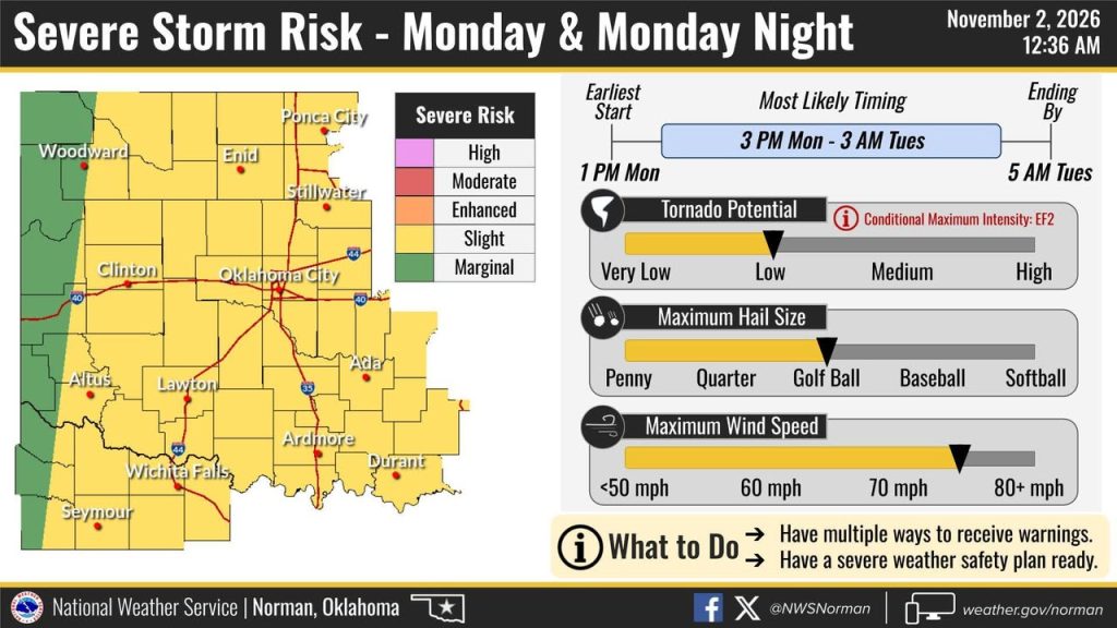
Tornado Watch issued November 2 at 1:27PM CST until November 2 at 10:00PM CST by NWS Norman OK
THE NATIONAL WEATHER SERVICE HAS ISSUED TORNADO WATCH 701 IN
EFFECT UNTIL 10 PM CST THIS EVENING FOR THE FOLLOWING AREAS

IN OKLAHOMA THIS WATCH INCLUDES 39 COUNTIES

IN CENTRAL OKLAHOMA

CANADIAN CLEVELAND GRADY
KINGFISHER LINCOLN LOGAN
MCCLAIN OKLAHOMA PAYNE
POTTAWATOMIE

IN NORTHERN OKLAHOMA

GARFIELD GRANT KAY
NOBLE

IN NORTHWEST OKLAHOMA

ALFALFA BLAINE DEWEY
ELLIS MAJOR WOODS
WOODWARD

IN SOUTHERN OKLAHOMA

CARTER GARVIN JEFFERSON
LOVE MURRAY STEPHENS

IN SOUTHWEST OKLAHOMA

CADDO COMANCHE COTTON
GREER HARMON JACKSON
KIOWA TILLMAN

IN WESTERN OKLAHOMA

BECKHAM CUSTER ROGER MILLS
WASH*TA

IN TEXAS THIS WATCH INCLUDES 8 COUNTIES

IN NORTHERN TEXAS

ARCHER BAYLOR CLAY
FOARD HARDEMAN KNOX
WICHITA WILBARGER

THIS INCLUDES THE CITIES OF ALTUS, ALVA, ANADARKO, ARCHER CITY,
ARDMORE, ARNETT, BLACKWELL, BLANCHARD, BURNS FLAT, CARMEN,
CHANDLER, CHEROKEE, CHEYENNE, CHICKASHA, CLINTON, CONCHO,
CORDELL, CROWELL, DAVENPORT, DAVIS, DUNCAN, EL RENO, ELK CITY,
ENID, FAIRVIEW, FARGO, FREDERICK, GAGE, GEARY, GRANITE, GUTHRIE,
HAMMON, HELENA, HENNESSEY, HENRIETTA, HINTON, HOBART, HOLLIDAY,
HOLLIS, KINGFISHER, KNOX CITY, LAKESIDE CITY, LAMONT, LAWTON,
LEEDEY, LINDSAY, MANGUM, MARIETTA, MEDFORD, MEEKER, MOORE,
MUNDAY, MUSTANG, NEWCASTLE, NORMAN, OKARCHE, OKEENE,
OKLAHOMA CITY, PAULS VALLEY, PERRY, PONCA CITY, POND CREEK,
PRAGUE, PURCELL, QUANAH, RINGLING, RYAN, SAYRE, SCOTLAND,
SEILING, SENTINEL, SEYMOUR, SHATTUCK, SHAWNEE, SHEPPARD AFB,
SNYDER, STILLWATER, STROUD, SULPHUR, TALOGA, TEMPLE,
THACKERVILLE, TUTTLE, VERNON, VICI, WAKITA, WALTERS, WATONGA,
WAURIKA, WEATHERFORD, WELLSTON, WICHITA FALLS, WOODWARD,
WYNNEWOOD, AND YUKON.
null

11/02/2026
11/02/2026
10/27/2026

Urgent: City of Cushing Alert: Water Outage effecting Fourth Street from Thompson to Howerton today (10/27/26) 10am to 4:30pm.

Address

100 Judy Adams Boulevard
Cushing, OK
74023

Telephone

+19182250277

Website

Alerts

Be the first to know and let us send you an email when Cushing Emergency Management posts news and promotions. Your email address will not be used for any other purpose, and you can unsubscribe at any time.

Contact The Organization

Send a message to Cushing Emergency Management:

Shortcuts

Share