Clay County, Florida Emergency Management

  • Home
  • Clay County, Florida Emergency Management
Call Directions Website Contact the organization

Clay County, Florida Emergency Management The official page of Clay County Florida Emergency Management.
12/11/2026
06/11/2026
03/11/2026

We all have a hand in protecting the water that goes down our drains!

02/11/2026

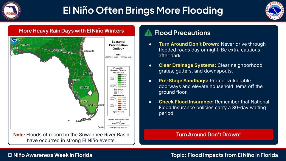
Localized flooding will be possible through Tuesday, primarily along the I-95 corridor/Atlantic coast in northeast Florida later today overnight into Monday. Rainfall amounts 1/2” to 2” with localized amounts up to 3 to 4” possible for Northeast FL.

27/10/2026

OCTOBER 27, 2026 - 2:30 PM UPDATE:
4300 Block Cedar Rd
Williams Park Rd near the bridge

We'll update this list as conditions change. Stay safe, Clay County!

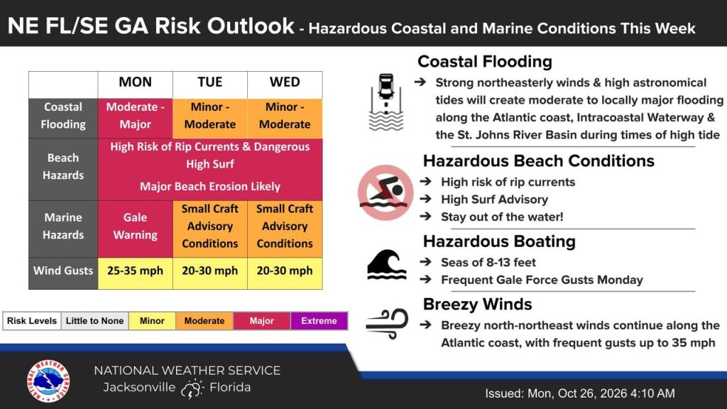
Monday 10/26/26 8:45 am⚠️ Today's tidal flooding will be 0.2-0.5 ft higher than yesterday's peak levels for most👉 Do NOT...
26/10/2026

Monday 10/26/26 8:45 am
⚠️ Today's tidal flooding will be 0.2-0.5 ft higher than yesterday's peak levels for most
👉 Do NOT drive through flooded roads
🚧 Do NOT drive around barricades
📍 Avoid the flood prone areas
Monitor local water levels here: https://water.noaa.gov/wfo/JAX
Click on each gage to see what "Moderate" level tidal flooding means for each location and what potential impacts are near the gage.
Local tides: https://weather.gov/jax/marineTides

MINOR FLOODING ALERT: Minor flooding is ongoing along tidal portions of Black Creek. Minor flooding will continue around...
10/10/2026

MINOR FLOODING ALERT:

Minor flooding is ongoing along tidal portions of Black Creek. Minor flooding will continue around the times of high tide through Sunday with peak values near 15 ft.

A gradual fall into action stage is expected next week.

River Flood Impacts
At 15 feet: Water begins to enter backyards of residential properties along Hawk Haven Rd & Lazy Acres Road & Redbug Alley on the north bank of the North Fork. Flooding begins at Enchanted Lane on the south bank of the North Fork.

At 15.5 feet: Flooding begins further downstream of the Blanding Blvd Bridge along North & South Lee.
Flooding begins on areas of the south bank of the North Fork, particularly at Scenic Drive and Enchanted Lane.

Stay weather aware. We'll continue to monitor the conditions and keep our community updated.

Northeast FL & Southeast GA forecast:- Hurricane Isaias to our west, making landfall later today near the central Gulf c...
09/10/2026

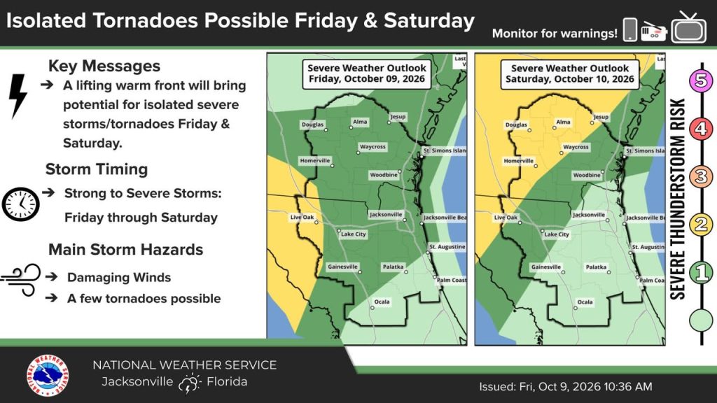
Northeast FL & Southeast GA forecast:
- Hurricane Isaias to our west, making landfall later today near the central Gulf coast - check hurricanes.gov for updates.
- Increasing isolated tornado threat today & Saturday as a warm front lifts northward.
- Heavy rainfall may lead to flooding, Flood Watch in effect areawide
- Continuing coastal/marine hazards (high rip current risk, gusty winds, beach erosion, Small Craft Advisory)
- Minor Tidal flooding along St. Johns river basin
Track forecast updates at weather.gov/jax and ensure you have multiple ways to receive weather alerts.

Address


Alerts

Be the first to know and let us send you an email when Clay County, Florida Emergency Management posts news and promotions. Your email address will not be used for any other purpose, and you can unsubscribe at any time.

Contact The Organization

Send a message to Clay County, Florida Emergency Management:

Shortcuts

  • Want your organization to be the top-listed government service?

Share